HOME | ABOUT | ARTISTS | SONG SEARCH | SHOP | VIDEOS | REGIONS | STATE LIST | GALLERIES | PODCASTS | AMERICAN SPOTLIGHT | GAMES | F.A.Q. | CONTACT |

|
American Spotlight Great Coastal Mountains of AmericaAmerica’s Great Coastal Mountains: Where the Land Rises from the SeaThe coastline of the United States is often imagined as a meeting place between land and water: sandy beaches, rocky headlands, quiet coves, and long stretches of open ocean. Yet in many parts of the country, the land does not simply meet the sea. It rises above it. From the rounded granite summits of coastal Maine to the fog-draped ranges of California, from the rain-soaked wilderness of Washington’s Olympic Mountains to the immense glaciated peaks of Alaska, America possesses one of the most varied collections of coastal mountain landscapes on Earth. Some of these mountains stand only a few thousand feet high, but rise so abruptly from the water that they dominate the horizon. Others tower more than three miles above nearby tidewater, wrapped in glaciers and surrounded by some of the wildest country remaining in North America. Together, these ranges tell a larger geological and geographical story. They reveal the tremendous forces that have shaped the continent: colliding tectonic plates, rising magma, ancient glaciers, relentless waves, and rivers of ice. They also demonstrate that the phrase “coastal mountain” can describe many different kinds of landscapes, from Maine’s exposed granite domes to Alaska’s colossal walls of snow and stone.
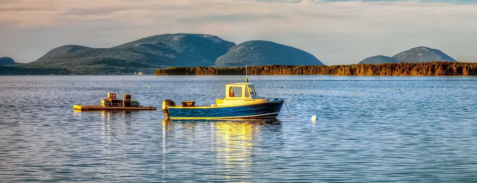
Maine: Granite Mountains Beside the AtlanticThe eastern journey begins along the rocky coast of Maine, where the mountains are modest in elevation but unusually dramatic in appearance. The most famous are the mountains of Mount Desert Island, protected within Acadia National Park. Here, rounded granite summits rise almost directly above the Atlantic Ocean. Cadillac Mountain, the highest point on the island, reaches 1,530 feet. Compared with the Rockies, Cascades, or Sierra Nevada, that elevation may appear small. Yet the mountain begins near sea level, and its broad, exposed summit commands an enormous panorama of islands, bays, forests, villages, and open ocean. The mountains of Acadia are sometimes described as “bald” because many of their upper slopes and summits are covered not by deep forests or soil, but by broad expanses of exposed pink and gray granite. These surfaces were sculpted and polished by enormous continental glaciers that once covered New England. As the ice moved across the landscape, it scraped away weathered rock and soil, leaving behind rounded domes, steep cliffs, glacial grooves, scattered boulders, and long north-to-south valleys. Cadillac Mountain is the best-known of Acadia’s peaks, but the park contains an entire compact range. Dorr Mountain, Sargent Mountain, Penobscot Mountain, Champlain Mountain, Pemetic Mountain, and several others create an intricate landscape of ridges, ravines, ponds, and bare rock. Some rise above narrow bodies of water such as Jordan Pond, where the rounded summits known as the Bubbles form one of the park’s most recognizable scenes. Others stand directly behind the ocean, as Champlain Mountain does above Frenchman Bay. The result is a coastal mountain landscape unlike any other in the United States. It is intimate rather than immense. A visitor can move within a few miles from crashing surf and rocky beaches to spruce forests, quiet lakes, granite cliffs, and open mountain summits. Acadia’s mountains are also part of the Appalachian story. They represent remnants of ancient mountain-building events that occurred hundreds of millions of years ago, long before the Atlantic Ocean existed in its present form. Time, erosion, and glaciation have worn those once-great mountains down, but their granite foundations remain. Beyond Mount Desert Island, the mountains of Maine continue along the coast in scattered but beautiful forms. The Camden Hills rise above Penobscot Bay, creating one of New England’s most picturesque combinations of mountain, forest, village, and sea. From Mount Battie and Mount Megunticook, the view extends across Camden Harbor and the island-filled waters beyond. Maine’s coastal mountains may not possess the altitude of the western ranges, but they have something equally compelling: a sense that the Atlantic has pushed directly against the ancient bones of the continent. The Appalachian Coast Beyond MaineSouth of Maine, mountains and sea gradually begin to separate. The Appalachian highlands retreat inland through New Hampshire, Massachusetts, and the Mid-Atlantic states. Coastal New England retains rocky hills and prominent headlands, but few true mountain ranges rise directly from the ocean. This interruption makes Maine’s coastal mountains even more unusual. Along much of the Atlantic seaboard, the land between the Appalachians and the ocean consists of rolling uplands, broad river valleys, coastal plains, wetlands, and barrier islands. Only after crossing the continent does the great pattern of coastal mountains begin again, this time on a much larger and more geologically active scale. California: A Coast Shaped by MountainsCalifornia possesses the longest and most varied system of coastal mountain ranges in the contiguous United States. Rather than forming one continuous wall, the California Coast Ranges are divided into a complex collection of ridges, valleys, faults, and smaller mountain systems extending for hundreds of miles. They run from the mountains near Santa Barbara and Los Angeles through the central coast and San Francisco Bay region, continuing northward toward the Oregon border. These mountains define much of California’s coastal identity. They create the cliffs of Big Sur, surround the valleys of the wine country, rise behind major cities, redirect rivers, trap fog, and separate the Pacific shoreline from California’s great interior valleys. Southern California’s Coastal MountainsIn Southern California, several mountain ranges rise abruptly near the sea. The Santa Monica Mountains stretch westward through Los Angeles County to Point Mugu, forming a rugged divide between the Los Angeles Basin and the Pacific coast. Their dry slopes are covered in chaparral, coastal sage scrub, oak woodland, and pockets of riparian vegetation. Although surrounded by one of the largest metropolitan areas in North America, the Santa Monica Mountains preserve surprisingly wild landscapes. Mountain lions, coyotes, bobcats, mule deer, and golden eagles survive within a patchwork of public lands, communities, highways, and canyons. Farther west, the Santa Ynez Mountains rise sharply behind Santa Barbara. Unlike most of California’s mountain ranges, which generally trend north to south, the Santa Ynez Mountains run east to west. Their steep southern face towers above the coastal plain, creating a spectacular backdrop of sandstone ridges and chaparral-covered slopes. In some places, the mountains stand only a few miles from the Pacific. From higher elevations, the Channel Islands appear across the water, while the developed coastline lies far below. Southern California’s coastal mountains are shaped by a Mediterranean climate. Summers are typically dry, while most precipitation falls during the cooler months. Wildfire, drought, flash floods, and landslides are recurring natural forces. The mountains may appear golden and dry for much of the year, only to become briefly green after winter rains. Big Sur: Mountains Falling into the PacificThe most dramatic meeting of mountain and ocean in California occurs along Big Sur. Here, the Santa Lucia Mountains rise steeply from the Pacific Ocean. In places, the terrain climbs from sea level to several thousand feet within only a few miles. Narrow canyons descend toward hidden beaches, while immense ridges drop into the ocean in a succession of cliffs, coves, rock formations, and forested slopes. Big Sur’s coastal landscape is among the most celebrated in the United States because it combines so many powerful visual elements: restless ocean, towering cliffs, deep ravines, windswept grasslands, redwood groves, fog, and mountains. The road through Big Sur, California Highway 1, is famous precisely because the terrain is so difficult. It curves along cliff faces, crosses high bridges, and passes through areas frequently affected by rockfalls and landslides. The highway does not conquer the mountains so much as cling to them. The Santa Lucia Mountains contain one of the steepest coastal slopes in the contiguous United States. Cone Peak rises more than 5,000 feet within only a few miles of the Pacific, producing an extraordinary sense of vertical relief. The vegetation changes rapidly with elevation, slope direction, and moisture. Coastal scrub and grasslands occupy exposed areas, while oak woodland and chaparral cover warmer slopes. In shaded canyons, fog and moisture support groves of coast redwoods. These redwoods do not dominate the entire Big Sur landscape, but where they occur, they add another layer of grandeur to the mountains. Big Sur represents California’s coastal ranges at their most dramatic: young, unstable, steep, and constantly reshaped by tectonic forces, storms, erosion, and the sea. The Central and Northern Coast RangesNorth of Big Sur, the coastal mountains continue around the San Francisco Bay region and through the wine country. The Santa Cruz Mountains rise along the San Francisco Peninsula and southward toward Monterey Bay. Though surrounded by major population centers, they contain dense redwood forests, steep watersheds, fault zones, and remote ridges. North of San Francisco Bay, the Coast Ranges become broader and more complex. The Mayacamas Mountains, Sonoma Mountains, Marin Hills, and other ranges shape the valleys and climates of Napa and Sonoma counties. Their ridges influence where fog travels, where rainfall falls, and where vineyards thrive. Farther north, the mountains become increasingly rugged and forested. The Mendocino Range and neighboring highlands rise above a coastline of cliffs, sea stacks, hidden beaches, and river mouths. The terrain is often remote, with fewer highways and communities than along the central and southern coast. Eventually, the northern Coast Ranges approach the Klamath Mountains, a geologically complex region extending into southwestern Oregon. These mountains contain ancient rocks assembled from fragments of crust that formed in different places and were gradually added to the western edge of North America. Northern California’s coastal mountains also shelter the world’s tallest forests. Coast redwoods grow in a narrow, fog-influenced belt where moist air from the Pacific helps sustain them through the dry summer months. Here, the coastal mountains do more than form scenery. They interact with ocean currents, fog, rainfall, and topography to create one of the most remarkable forest ecosystems on Earth. Oregon: Forested Ranges Along the PacificThe Oregon Coast Range extends between the Pacific Ocean and the Willamette Valley. It does not generally possess the high, rocky summits associated with the Cascades, but it forms a long, deeply forested mountain system that defines much of western Oregon. These mountains are green, rounded, and heavily dissected by rivers and streams. Their slopes support dense forests of Douglas fir, western hemlock, Sitka spruce, red cedar, and other moisture-loving species. Unlike the exposed granite of Maine or the dry chaparral ridges of Southern California, Oregon’s coastal mountains are often softened by vegetation. Forests cover the ridgelines, fill the valleys, and descend nearly to the beaches. Yet the Oregon coast is far from gentle. Headlands project into the Pacific, waves strike dark cliffs, and offshore sea stacks rise like remnants of a drowned mountain landscape. Cape Perpetua, Cape Lookout, Neahkahnie Mountain, and other high points provide sweeping views along the coast. The Coast Range also intercepts moist Pacific air, producing heavy rainfall on west-facing slopes. This moisture feeds countless streams and rivers, creating important habitat for salmon and other aquatic species. In many places, Oregon’s mountains stand just inland from a narrow coastal strip. The result is a landscape of compact transitions: beach, headland, forest, river estuary, and mountain ridge may all lie within a relatively small area. Although lower than the nearby Cascade Range, the Oregon Coast Range is a major geographical barrier. It separates the marine environment of the coast from the agricultural Willamette Valley and plays a central role in the climate, ecology, and settlement patterns of western Oregon. Washington’s Olympic Mountains: A Wilderness Raised from the SeaNorth of the Columbia River, Washington’s coastal mountains become higher, colder, and more formidable. The Olympic Mountains occupy the heart of the Olympic Peninsula, surrounded on three sides by water: the Pacific Ocean to the west, the Strait of Juan de Fuca to the north, and Puget Sound and Hood Canal to the east. Unlike the volcanic Cascade Range farther inland, the Olympics were formed largely from oceanic rocks and sediments that were scraped, folded, fractured, and uplifted along the edge of the continent. Their geological history is tied directly to the collision between tectonic plates beneath the Pacific Northwest. The range is compact but exceptionally rugged. Mount Olympus, its highest summit, rises to nearly 8,000 feet. While this elevation is modest compared with Mount Rainier or the highest peaks of the Rockies, the Olympics begin near sea level and receive enormous quantities of snow and rain. The western side of the range faces directly into moisture-laden Pacific weather systems. As air rises over the mountains, it cools and releases heavy precipitation. This produces one of the wettest environments in the contiguous United States. At lower elevations, that moisture sustains the temperate rainforests of the Hoh, Quinault, and Queets valleys. Massive Sitka spruce, western hemlock, Douglas fir, and red cedar grow beneath canopies draped with mosses and lichens. Ferns cover the forest floor, and fallen trees become nurseries for new growth. Above the rainforests, the Olympic Mountains rise into alpine country filled with jagged peaks, glaciers, snowfields, rocky ridges, and wildflower meadows. The range contains numerous glaciers, particularly around Mount Olympus. These glaciers are remnants of a colder climatic past, but they continue to shape the mountains by carving valleys, transporting rock, and feeding rivers. The Olympic Mountains are especially remarkable because they remain largely roadless in their interior. Roads circle the peninsula and enter some major valleys, but none crosses the heart of the range. Much of the interior can be reached only by trail. This isolation has protected a vast mountain wilderness surprisingly close to major cities such as Seattle, Tacoma, and Victoria, British Columbia. The Olympics also create one of the strongest rain shadows in North America. After Pacific air masses lose much of their moisture on the western slopes, they descend toward the northeastern peninsula. Communities such as Sequim receive far less rainfall than the rainforests only a relatively short distance away. Few American mountain ranges influence their surrounding region so dramatically. The Olympics create rainforests, glaciers, rivers, rain shadows, and entire climatic zones within a compact peninsula bordered by the sea.
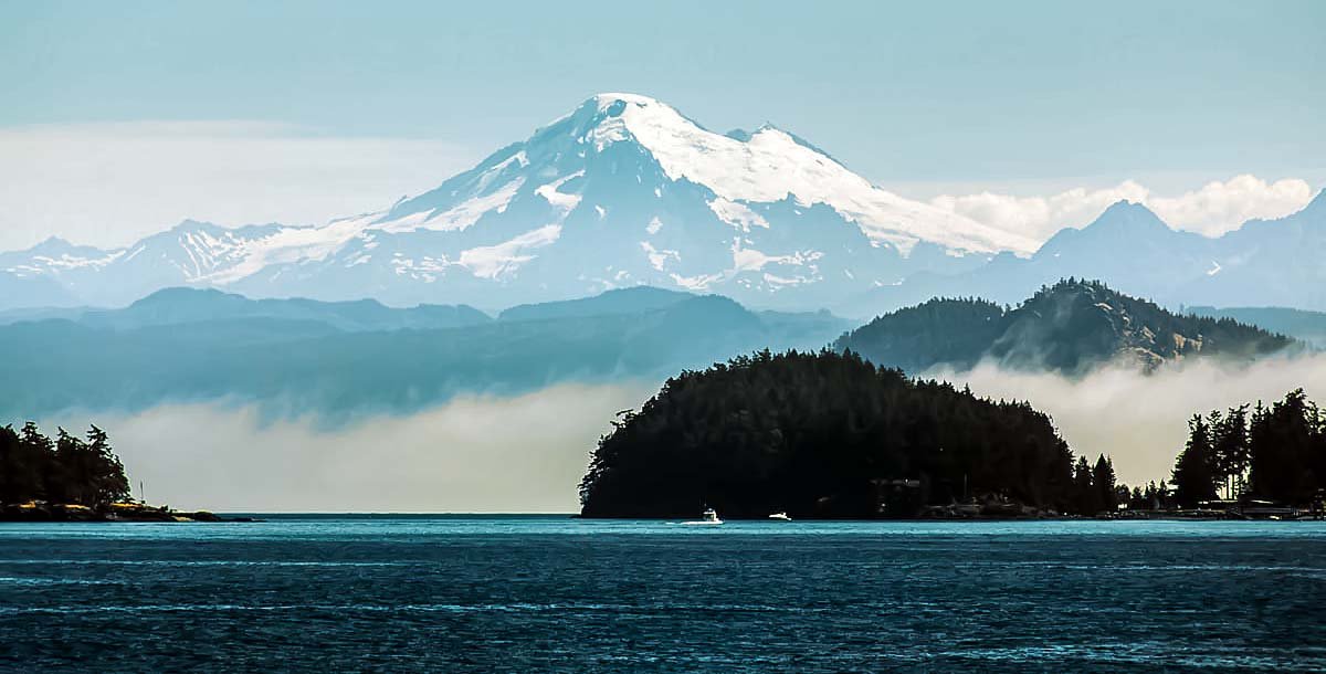
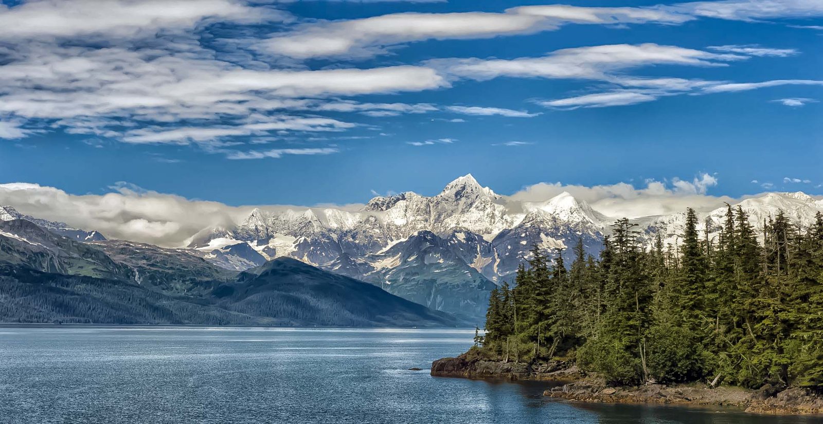
The Mountains of Puget Sound and the North CascadesAlthough the Cascade Range is not usually classified as a coastal range in the narrowest sense, western Washington’s geography makes the Cascades an essential part of the nation’s coastal mountain story. From islands and shorelines around Puget Sound, the Cascade Mountains rise dramatically to the east. Mount Baker, Glacier Peak, and Mount Rainier stand high above the lowlands, often appearing to float above layers of cloud and mist. The North Cascades are particularly rugged. Their dark ridges, sharp summits, glaciers, and deep valleys have earned them comparisons to the European Alps. Rivers descending from these mountains eventually reach Puget Sound or the Pacific, linking the high country to the coastal environment. The result is a broader maritime mountain landscape. Washington’s coast is influenced not by one range alone, but by the combined presence of the Olympics to the west and the Cascades to the east. Between them lies the complex network of islands, bays, channels, and lowlands surrounding Puget Sound. In few other places does a major urban region sit so completely between two mountain systems. Alaska: Where Coastal Mountains Become GiantsThe coastal mountains of Alaska exist on a scale unlike anything in the Lower 48. Here, vast ranges rise directly from fjords, inlets, islands, and the Gulf of Alaska. Glaciers descend from high icefields toward the sea. Entire mountain walls remain unnamed, roadless, and seldom visited. Storms arriving from the North Pacific release immense quantities of snow, feeding some of the largest nonpolar icefields in the world. Alaska’s coastal ranges are not a single simple chain. They include several connected or neighboring mountain systems, among them the Coast Mountains of southeastern Alaska and British Columbia, the Saint Elias Mountains, the Chugach Mountains, and the Kenai Mountains. Each possesses its own character, but all are defined by the extraordinary interaction of mountains, ocean, ice, and tectonic forces. The Coast Mountains of Southeast AlaskaSoutheast Alaska consists of a narrow mainland strip and a vast archipelago of forested islands known as the Alexander Archipelago. Behind the islands, the Coast Mountains rise steeply along the border with Canada. These mountains are heavily glaciated, deeply cut by fjords, and covered at lower elevations by temperate rainforest. Communities such as Juneau, Sitka, Ketchikan, and Petersburg occupy narrow strips of habitable land between mountains and water. In many places, roads extend only a short distance before cliffs, forests, glaciers, or channels make further travel impossible. Juneau, Alaska’s capital, is inaccessible by road from the rest of the North American highway system. The city is hemmed in by mountains, icefields, and the sea. Behind it lies the Juneau Icefield, an immense expanse of interconnected glaciers extending across the international border. The famous Mendenhall Glacier descends from this icefield toward the outskirts of Juneau, offering a visible reminder that Alaska’s coastal mountains are still actively shaped by ice. Southeast Alaska’s mountains resemble the Pacific Northwest in some respects. They receive heavy precipitation, support dense conifer forests, and rise above intricate coastlines. Yet the landscape is larger, colder, and more thoroughly dominated by glaciers. The forests themselves are part of the great coastal temperate rainforest extending from northern California through Oregon, Washington, British Columbia, and southeastern Alaska. In Alaska, Sitka spruce and western hemlock cover the lower slopes, while snowfields and bare rock dominate the elevations above. The Saint Elias Mountains: The Greatest Coastal Relief on EarthAlong the Gulf of Alaska, near the border with Canada, the Saint Elias Mountains rise with astonishing abruptness. This is one of the youngest, highest, and most tectonically active mountain regions in North America. The mountains are being raised by the collision of crustal fragments and tectonic plates along the southern coast of Alaska. Mount Saint Elias reaches 18,008 feet, making it the second-highest mountain in both the United States and Canada. Its summit stands only about 35 miles from the sea. Few mountains anywhere on Earth rise so high so close to an ocean. From its upper slopes, the land descends through glaciers and broken ridges toward the Gulf of Alaska. The Saint Elias region contains some of the greatest vertical relief on the planet. Peaks rise from tidewater and low coastal terrain to elevations exceeding 15,000 and 18,000 feet. Vast glaciers flow between them, forming moving rivers of ice many miles long. Mount Fairweather, despite its optimistic name, stands in one of the stormiest regions of North America. Rising to 15,325 feet near the Gulf of Alaska, it towers above Glacier Bay and the surrounding wilderness. The mountains around Glacier Bay create one of America’s most extraordinary coastal landscapes. Here, glaciers have carved deep fjords and steep-sided valleys. Some glaciers reach tidewater, where chunks of ice break away and crash into the sea. The coastline itself has changed dramatically over the past several centuries as glaciers advanced and retreated. Areas once buried beneath thousands of feet of ice are now occupied by water, forests, wetlands, and newly exposed land. The Saint Elias Mountains are so heavily glaciated that many individual peaks appear less like isolated mountains than pieces of a single immense frozen world. The Chugach Mountains: Snow Above Prince William SoundFarther west, the Chugach Mountains rise around Prince William Sound and extend toward the city of Anchorage. They are not as high as the Saint Elias Mountains, but they are among the snowiest mountains in the world. Moisture arriving from the Gulf of Alaska is forced upward over the range, producing tremendous snowfall. The Chugach landscape consists of steep peaks, deep fjords, forested islands, icefields, and glaciers. Prince William Sound penetrates deeply into the mountains, creating a maze of sheltered waterways surrounded by snow-covered ridges. Numerous glaciers descend toward the sound. Some end on land, while others reach tidewater. Columbia Glacier, one of the best known, has undergone major retreat in recent decades, illustrating how quickly Alaska’s coastal ice can respond to changing climatic conditions. The western Chugach Mountains also form the dramatic backdrop to Anchorage. From parts of the city, the mountains appear to rise almost immediately beyond the developed lowlands. Trails, alpine valleys, wildlife habitat, and extensive public lands lie within a short distance of Alaska’s largest urban area. South of Anchorage, the Seward Highway follows Turnagain Arm between the Chugach Mountains and the water. The route offers one of the clearest demonstrations of Alaska’s coastal geography: steep mountains on one side, tidal flats and narrow marine waters on the other. The Kenai Mountains: Fjords, Icefields, and the Gulf of AlaskaAcross Turnagain Arm, the Kenai Mountains extend along the Kenai Peninsula. These mountains are lower than the Saint Elias giants but remain rugged, heavily glaciated, and deeply influenced by the sea. The Harding Icefield covers a large portion of the range, feeding numerous glaciers that flow outward through valleys toward surrounding lowlands and fjords. Kenai Fjords National Park protects a landscape where glaciers, mountains, and ocean are inseparable. The coastline is carved into narrow fjords bordered by steep cliffs and ice-scoured valleys. Marine wildlife thrives in the surrounding waters, while bears, mountain goats, and other animals inhabit the mountains and forests. Exit Glacier provides relatively accessible evidence of the Harding Icefield’s reach, while more remote glaciers descend toward tidewater along the outer coast. The Kenai Mountains are a fitting continuation of the American coastal mountain story. Like Acadia, they have been profoundly shaped by ice. Like California’s ranges, they rise abruptly near the ocean. Like the Olympics, they intercept Pacific storms and support rich ecosystems. But in the Kenai Mountains, these characteristics occur on an unmistakably Alaskan scale. Why America’s Coastal Mountains Are So DifferentThe great variety among America’s coastal mountains comes from differences in age, geology, climate, latitude, and tectonic setting. Maine’s mountains are the deeply eroded remains of ancient geological events. They have been rounded and polished by continental glaciers, then exposed to the wind, rain, frost, and waves of the North Atlantic. California’s coastal ranges are younger and more tectonically active. They have been shaped by movement along faults, compression of the crust, uplift, erosion, fire, drought, and landslides. Oregon’s Coast Range consists largely of forested uplands strongly influenced by Pacific rainfall. Its rounded ridges lack the extreme altitude of Alaska, but they form a continuous ecological and climatic barrier along the coast. The Olympic Mountains originated from rocks and sediments associated with the ocean floor. They were uplifted and folded at the edge of the continent, then heavily sculpted by glaciers and precipitation. Alaska’s coastal mountains occupy one of the most active geological environments on the continent. Tectonic collisions continue to raise them, while immense snowfall and glacial ice carve them back down. Climate adds another layer of contrast.Maine experiences cold winters, humid summers, Atlantic storms, and brilliant autumn foliage. Southern California experiences prolonged summer drought, periodic winter rains, and frequent wildfire. Northern California, Oregon, and Washington receive cool marine air, winter storms, and coastal fog. Southeastern and south-central Alaska experience heavy precipitation, long winters, enormous snowfall, and extensive glaciation. The mountains also differ in their relationship to the sea. Some, like those of Acadia and Big Sur, rise directly above open ocean. Others stand beside protected channels, bays, or sounds. Alaska’s ranges surround fjords that carry seawater deep into the mountain interior. Mountains That Shape the CoastCoastal mountains are not simply scenic objects standing beside the ocean. They actively shape the lands and waters around them. They influence rainfall by forcing moist air upward. They create rain shadows on their leeward sides. They feed rivers and streams. They determine where forests grow, where settlements can be built, and where roads can travel. They also create habitat transitions within remarkably short distances. A journey from the shoreline to a mountain summit may pass through tidal ecosystems, coastal forest, upland woodland, subalpine meadow, bare rock, snowfield, and glacier. In Alaska and the Pacific Northwest, mountain-fed rivers support salmon migrations that connect marine and terrestrial ecosystems. Fish born in mountain streams travel to the ocean and later return inland, carrying nutrients that ultimately feed bears, eagles, forests, and countless other organisms. In California, the coastal ranges help trap fog and moisture essential to redwood forests. They also create valleys and microclimates that support farms, vineyards, oak woodlands, and a tremendous diversity of plant life. In Maine, the coastal mountains create sheltered harbors, island-filled panoramas, glacial lakes, and a rugged meeting point between Appalachian geology and the Atlantic Ocean. Human communities have had to adapt to these mountain barriers. Roads wind through passes and along cliffs. Towns occupy narrow valleys, river mouths, and coastal benches. In parts of Alaska, boats and aircraft remain more practical than highways. These mountains inspire recreation, art, music, photography, and literature, but they also demand respect. Storms, avalanches, wildfires, landslides, earthquakes, rockfalls, tides, and rapidly changing weather are natural parts of the coastal mountain environment. From Granite Domes to Glacial GiantsViewed together, America’s coastal mountains form a remarkable continental progression. In Maine, ancient granite summits rise above the cold blue Atlantic, their rounded surfaces polished by glaciers that disappeared thousands of years ago. In California, younger and more restless mountains plunge toward the Pacific through chaparral, redwood forest, fault zones, cliffs, and canyon country. In Oregon, long forested ridges gather rain and stand behind a coast of headlands, beaches, and sea stacks. In Washington, the Olympic Mountains lift glaciers and alpine wilderness above temperate rainforest, while the distant Cascades complete a landscape enclosed by water and peaks. Finally, in Alaska, coastal mountains reach their greatest scale. Peaks rise thousands of feet above fjords, glaciers flow toward tidewater, and entire ranges disappear into clouds, storms, snowfields, and wilderness. These landscapes differ profoundly, yet they share a defining quality: immediacy. The mountains do not wait far beyond the coast. They stand beside it, rise from it, and shape it. Along these shores, the meeting of land and ocean becomes something more than a boundary. It becomes a collision of elemental forces: rock against water, ice against mountain, forest against storm, and continent against sea. From the bald granite summits of Maine to the glacial giants of Alaska, America’s coastal mountains represent some of the most dramatic, varied, and beautiful terrain in the nation.
Related Songs & Products:All lyrics have been written by Mark S. McKenzie/American Storyteller Music and The Lyrical Horizon and produced by Story Teller Books and Music or Loud Mouth Books and Music, Copyright 2025, All Rights Reserved:
|










Seasonal Favorites: Our Featured Picks for Summer Season of 2026
 |
 |
 |
 |
 |
 |
.jpg) |
 |